Nestled amidst ocean and mountain vistas, Victoria stands out as one of Canada’s most picturesque cities. The hiking trails scattered across and around the city capitalize on the region’s natural splendor, providing quick getaways to summits, waterfalls, and even historical sites. Whether within Victoria or up to 1.5 hours away, these trails effortlessly transport you from the city’s hustle and bustle to the tranquility of the wilderness.
These trails offer a diverse range of experiences, from leisurely walks along the seaside or lakeside to strolls through ancient forests and invigorating mountain hikes. Regardless of your skill level, there is a trail suited to your preferences. Trailheads are marked, often accompanied by maps, and the trails are meticulously maintained. Most hiking paths remain accessible year-round and are welcoming to dogs, provided they are leashed. Plan your outdoor adventure with our curated list of the best hikes near Victoria.
1. Coast Trail, Sooke
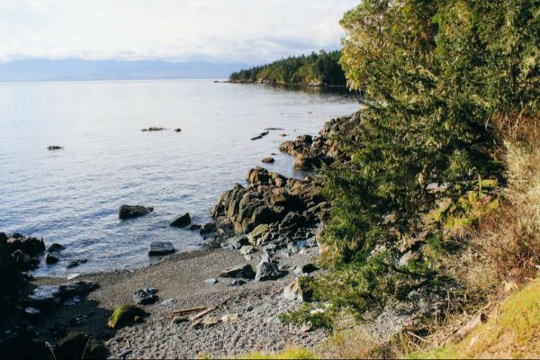
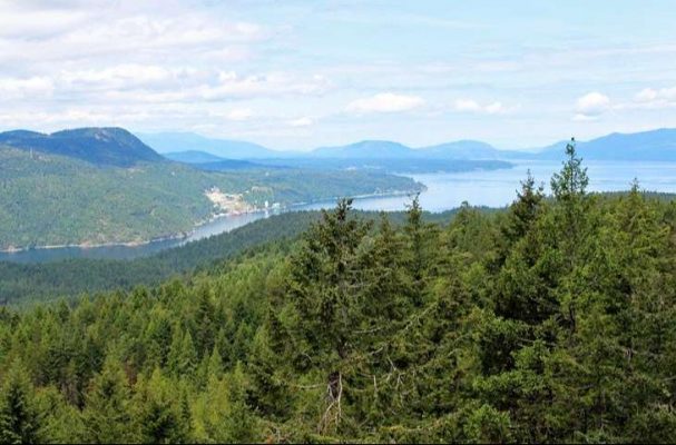
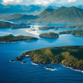
While numerous trails around Victoria lead to peaks or inland attractions, hiking along the coast offers a spectacular experience. The Coast Trail near Sooke stands out as one of the most beautiful hiking areas, providing breathtaking views of the snow-capped Olympic Mountains and opportunities to relax on soft-sand beaches.
This is a 10-kilometer one-way trail, but most hikers opt to complete only a section of it. The most popular access point is from Aylard Farm. The trail starts at a delightful beach area, which is particularly popular on warm days, and then follows the coastline, weaving through trees and emerging onto rocks at intervals.
A noteworthy site along this hike is the petroglyphs. Positioned on a point overlooking the Juan De Fuca Strait, ancient images of a seal and a whale are inscribed on the rocks. While it can be easy to miss, a plaque marks the area.
The trail begins in East Sooke Regional Park, situated on a peninsula about 25 minutes from downtown Sooke or 45 minutes from downtown Victoria. The hike concludes at Iron Mine Bay, a spectacular small cove at the far end of the park. While the hike can be tackled in the reverse direction, the section from Iron Mine Bay heading south is considerably more challenging.
2. Mount Doug Hiking Trails
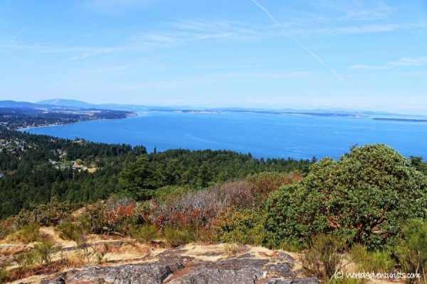
The Mount Doug hiking trail offers one of the finest viewpoints of Victoria, the surrounding areas, the Olympic Mountains, and, if fortunate, the imposing dome of Mount Baker.
Mount Doug features an intricate network of hiking trails, making navigation to the summit a bit perplexing. A detailed map is conveniently located at the park entrance, near the prominent sign that welcomes visitors at the primary parking lot off Cedar Hills Road.
Reaching the summit involves several challenging options, each demanding a strenuous uphill hike that will elevate your heart rate on the ascent and test your knees on the descent.
For those who prefer an uncomplicated route without complex navigation, continue walking up Churchill Drive beyond the gate, following its twists and turns for 1.5 kilometers to the top. The return journey is simply retracing the same path.
If you seek a more conventional hiking trail through towering trees, opt for the Irvine trail. The trailhead for this path starts from Churchill Drive on the right, just beyond the bicycle racks in the parking lot. The Irvine trail intersects Churchill Drive; ensure you stay to the right of the road heading uphill. Going left will still lead you to the top, but the route is longer, requiring connections with the Whitaker and Glendenning trails, which can be quite steep.
A popular choice that many people find enjoyable is taking the Irvine trail to the summit and descending back down Churchill Drive.
If the options seem overwhelming, you can drive to nearly the top of the mountain and cover the final short stretch on foot. Churchill Drive is open to cars from noon to dusk seven days a week.
3. Mount Tolmie
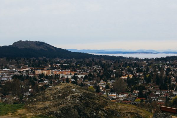
Mount Tolmie provides a delightful walking area conveniently located within the city. For those hesitant to venture into the wilderness alone, this presents an appealing option. Drive to the summit of Mount Tolmie to indulge in 360-degree views of Victoria before commencing your hike. The road winds through a picturesque neighborhood, ultimately leading to the mount’s peak.
Combine short trails around the parking area and summit to create a 1.2-kilometer loop. Throughout the hike, benches and scenic spots offer opportunities to relax and appreciate the panoramic views. Of particular interest at the summit is a substantial concrete slab dating back to WWII, once a component of Canada’s defense system. While parking at the summit is relatively limited, a more extensive lot is available a short distance down the hill.
4. Mount Work Hiking Trail
For a scenic experience coupled with a moderate workout, Mount Work is an excellent choice. From its summit, the southern views showcase the breathtaking Olympic Mountains, while northern views stretch down Saanich Inlet. This 4.5-kilometer trail meanders through diverse landscapes, featuring large fir, arbutus, and cedar trees, leading to two lookout points.
The summit provides expansive vistas, offering clear-day sightings beyond the ocean to the Olympic Mountains. The second viewpoint, just before the summit, overlooks Saanich Inlet and Mount Finlayson in the opposite direction.
The lookouts boast open rock areas, ideal for lunch or relaxation on pleasant days. The trail involves a relatively steady ascent with occasional steep sections followed by gentler inclines. The total elevation gain is 230 meters, and the trailhead is located at the Ross Durrance Road Parking Lot in Mount Work Regional Park.
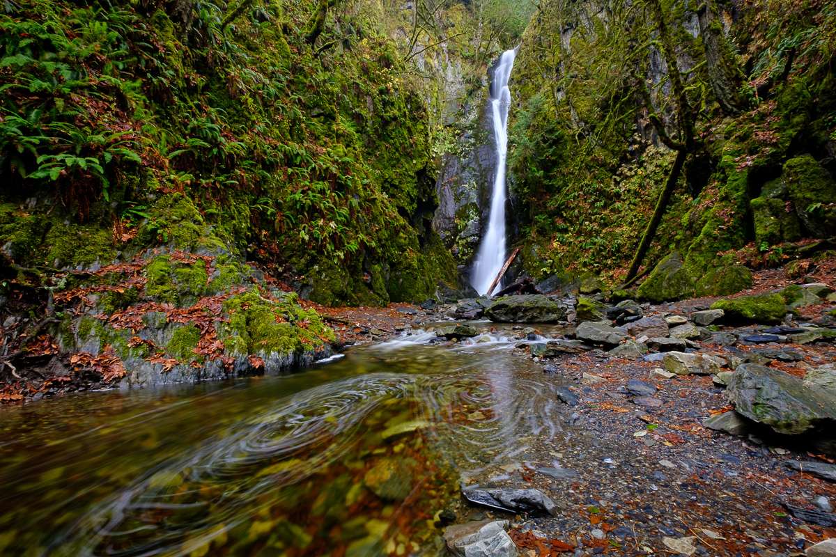
5. Niagara Falls Hiking Trail, Goldstream Provincial Park
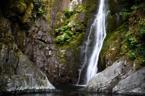
The trail’s name may sound grandiose, but it is certainly worth exploring, complete with a walk through a tunnel. Covering a relatively easy 1.3 kilometers round trip, it is an ideal choice for a family outing.
This hike leads to a magnificent 47-meter waterfall cascading down a sheer cliff face, surrounded by vibrant vegetation. Depending on your agility, you can walk and scramble right up to the deep pool at the falls’ base.
Access to the falls is possible from two parking areas, with one being small and unmarked, making it a bit challenging to locate. Most visitors start at the day-use area on the north side of the highway. The brief hike involves a path through a sizable yet short tunnel beneath the highway, continuing up the typically dry riverbed toward the falls. In case the river is flowing due to recent heavy rains, you’ll need to park at the small, unmarked parking area on the south side of the highway. From there, it’s just a few hundred meters to reach the falls.
Above Niagara Falls stands an abandoned railway bridge dating back to 1910. Previously, many people extended their hike beyond the falls to reach this bridge, relishing the experience of walking on it and enjoying views of Mount Finlayson. However, this trail is no longer viable, as access to the bridge has been blocked, and the trails leading to the area are now decommissioned.
6. Mount Finlayson Hiking Trail
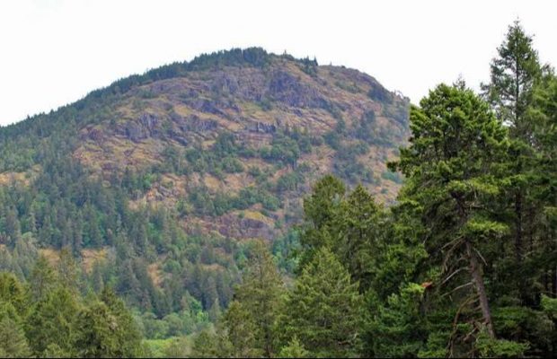
Mount Finlayson offers a challenging four-kilometer round-trip hike with a substantial elevation gain, granting panoramic 360-degree views of the surrounding areas. On clear days, Mount Baker can even be visible in the distance.
Two routes lead to the summit. The first route, starting from the day-use area, involves a 410-meter ascent through the forest, eventually reaching an open and exposed rock. Certain sections may require using your hands to aid in the steep climb. The second route, commencing from Finlayson Arm, is a milder, less frequented path resembling a traditional hiking trail. It is advisable to ascend and descend the same way to return to your original trailhead.
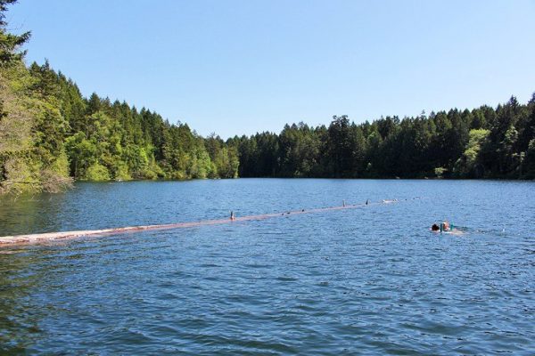
7. Thetis Lake Hiking Trail
Thetis Lake Regional Park is a versatile area attracting different preferences. Some visitors come to enjoy the beaches near the trail’s beginning, while others don their hiking boots to traverse the lake’s perimeter, divided into Upper and Lower Thetis Lakes. Among several trails in the vicinity, the more extended trail guides you from the water’s edge to elevated rocks, providing stunning viewpoints over the lake and encompassing both Lower and Upper Thetis Lakes.
In contrast to the ocean, the water in this area is warm and perfect for swimming. Many individuals choose to swim from the rocky shoreline during the hike, complemented by the presence of arbutus trees enhancing the scenery. The well-maintained five-kilometer loop trail varies in elevation as it encircles the lakes. One of the most picturesque segments of the trail follows the east side of the lake, leading to the summit of a rocky bluff.
8. Kinsol Trestle Bridge Trail
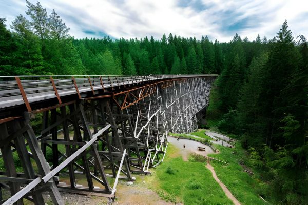
This hike, spanning three kilometers round-trip, traces the path of an old railbed. As anticipated, the trail maintains a flat and wide terrain, rendering it suitable for individuals of all skill levels. Enthusiasts engage in biking, horseback riding, or strolling with a stroller along the route. While the trail may lack dynamic features, the wooden trestle bridge at its conclusion stands out. As one of the world’s tallest free-standing timber trestle bridges, it reaches a height of 44 meters and spans 187 meters.
Noteworthy in its design, aside from its size, is the seven-degree curve inherent in the structure. The bridge, now featuring a flat boardwalk in place of railroad ties, invites pedestrians to traverse its length. At the bridge’s far end, a trail descends the bank, leading to the river and allowing walkers to explore beneath the bridge. Information boards at the trail’s outset and on the bridge, itself offer historical context and insights into the bridge’s construction and subsequent restoration.
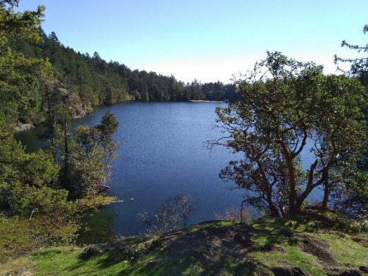
9. Durrance Lake Hiking Trail
Durrance Lake, situated in Durance Lake Regional Park, offers an uncomplicated and brief hike encircling a glistening blue lake enveloped by towering trees. The trail meanders past a picnic area and a small beach near its commencement, affording glimpses of Mount Work. With the lake warming up during the summer, it is advisable to bring along your bathing suit or, at the very least, pack a lunch to enjoy at the picnic tables positioned just a short distance from the water.
The 1.7-kilometer trail initiates with a wide path that gradually narrows as it forms a loop around the lake’s backside. Suited for hikers of all proficiency levels, this trail is an ideal choice. However, be mindful that the parking lot tends to fill up swiftly on warm weekends, and parking is not permitted on the access road.
Accommodation: Where to Stay in Victoria: Best Areas & Hotels
Read More: Best Things to Do in Victoria
FAQs
Q: Are these trails suitable for beginners?
A: Absolutely! Many trails cater to beginners, providing a gradual introduction to hiking in Victoria’s stunning landscapes.
Q: What’s the best time of year to explore these trails?
A: While Victoria’s mild climate allows year-round hiking, spring and summer offer pleasant weather and vibrant flora.
Q: Are there wildlife safety precautions to consider?
A: Yes, it’s advisable to be aware of potential wildlife encounters and follow park guidelines to ensure both human and animal safety.
Q: Can I camp along these trails?
A: Some trails, like the Juan de Fuca Marine Trail, offer camping options. Check with park authorities for specific regulations.
Q: Are these trails family-friendly?
A: Absolutely! Many trails, such as Thetis Lake and Francis King Park, are suitable for families with children, providing a safe and enjoyable experience.
Related posts:
 12 Top Tourist Attractions & Things To in Canada
 15 Top Tourist Attractions & Things to Do in Montreal
 15 Top Tourist Attractions & Things to Do in Vancouver, BC
 11 Top Tourist Attractions in Alberta, Canada
 12 Top Tourist Attractions & Places to Visit in Calgary
 12 Best Beaches in Ontario You Need to Vist
 12 Best Things to Do in Winnipeg
 11 Best Places to Visit in Kingston, Ontario
 10 Best Beaches in Toronto You Need to Visit this Summer!
 13 Best Hikes in Canada You Have to Try
 11 Best Things to Do in Glacier National Park
 9 Best Things to Do in Tofino, BC